The digital transformation of Calle 30: Fisotec’s innovation in urban mobility
The M-30, now known as Calle 30, represents much more than the modernization of an urban road. It embodies a mobility strategy aiming to redefine how citizens interact with the city of Madrid. This project aims to integrate the city, reduce accidents, minimize pollution, expand green areas, reclaim the Manzanares river, and improve overall mobility. Fisotechas been a cornerstone in this transformation.

Calle 30 Project: Comprehensive Transformation of the M-30
The M-30, once a symbol of progress and urban development in the Spanish capital, has become recognized as an obsolete infrastructure that, rather than connecting, divides the city. The transformation from M-30 to Calle 30 goes beyond mere road modernization and addresses various facets of urban development and mobility in Madrid. Key objectives include:
- Integrating the city:
- Problem: The M-30 acted as a physical barrier in the city, splitting neighborhoods and hindering connections among residents.
- Solution: The proposed remodeling and underground work aim to eliminate this barrier effect, uniting neighborhoods and easing the connection between citizens. The plan also aims to create gathering areas and enhance the quality of life.
- Reducing accidents:
- Problem: The high accident rate on the M-30 is twice that of other roads like the M-40.
- Solution: The Reform Plan proposes a complete modernization of the road, hoping to reduce the accident rate by almost 50%, representing substantial cost savings.
- Minimizing pollution:
- Problem: High emissions and noise pollution impact not only the environment but also nearby residents.
- Solution: There are hopes to reduce CO2 emissions and noise pollution with design improvements and burying sections of the road.
- Expanding green areas:
- Goal: Create at least 50 new hectares of public green areas around the Manzanares river.
- Method: Bury road sections and reclaim land, also promoting citizen participation in designing these spaces.
- Reclaiming the Manzanares river:
- Goal: Make the river accessible to citizens and improve its ecological status.
- Method: Remove barriers, replace the collector system, and prevent pollutant discharges.
- Improving mobility:
- Problem: The M-30, a crucial artery for mobility in Madrid, experiences flow and congestion issues.
- Solution: The reform seeks significant travel time savings and enhanced traffic flow.

What was Fisotec’s objective in these actions?
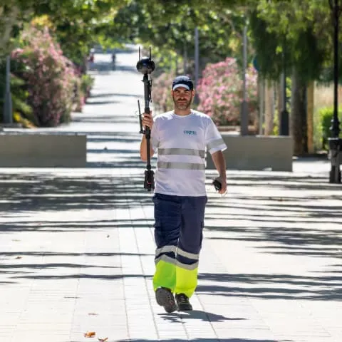
Faced with the challenges posed by the heavy traffic on Calle 30, Fisotec took on a specific goal: identify all public lighting installations and vertical signage. The correct identification and mapping of these structures are vital for future urban management decisions and mobility planning.
What was the nature of Fisotec’s work, and what were the results?
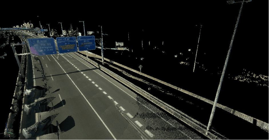
The process Fisotec undertook began with the use of the Leica Pegasus laser scanner mounted on a vehicle. This advanced technology allows for precise capture of the point cloud of the study area, forming the basis for creating a BIM (Building Information Modeling) model.
The outcome has been the generation of a detailed and accurate BIM model. This model serves as an invaluable resource for future interventions and improvements in urban maintenance. Thanks to the precision of the laser scanning, the created BIM model provides a faithful representation of reality, ensuring that all installations, from lighting to traffic signs, are perfectly mapped and cataloged.

Laser Scanning with Leica Pegasus
Leica Pegasus is not your conventional laser scanner. It represents the cutting edge in mobile mapping solutions, offering an integrated hardware platform that ranges from cameras to lidar profilers. Its ability to capture calibrated images and point cloud data simultaneously ensures no object goes unnoticed.
One of Leica Pegasus’s most outstanding features is its ability to record a complete 360° spherical view along with Lidar data. This means the area in question is captured in its entirety, eliminating the need for repeated site visits.
Need advice on your next urban project? Contact us at hello@fisotecsolutions.com